A couple of days ago, I was with a private pilot student and we had to deal with low clouds on departure and arrival back to the airport. The experience and seeing the reaction of my student made me think about writing this piece.
Let’s talk about getting trapped by clouds, up or down. Throughout my flying journey, I had my own experiences of getting trapped by clouds and to figure a way out of them, usually through a hole in the sky. Of course, if you have your instrument rating and flying an IFR-certified plane, then clouds are a non-issue. What if we don’t have instrument rating or the plane is not certified? That is what we will discuss in this post.
PLAN BEFORE LEAVING EARTH
It is a mystery how us, pilots, make better decisions on the ground than in the air, isn’t it? Well, it is actually not. It makes perfect sense. I, personally, make better decisions in my office with a cup of coffee in my hands. This is why, I remind my students over and over again: Always have alternative plans before you leave earth and take up to the skies. Especially as a VFR pilot, you should have a very good understanding cloud coverage and forecasts in your local area and of your route of flight. You may think that is common sense. It is however amazing how VFR pilots find themselves in clouds or get stuck above or below. There are many tools you can use to get an idea of where clouds will be. The EFB of your choice will most likely have some weather products as well. Here are two examples of what I use, and both are completely free!
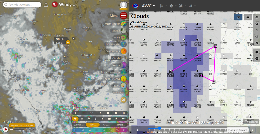
On the left, you see the app called Windy, specifically Cloud Layers with the HRRR model enabled. I’ve always were impressed on how accurate this model is when it comes to predicting cells and overall convective activity. HRRR model can predict cloud coverage and heights up to two days. If you must look at cloud forecast beyond two days, ECMWF model works well, but remember, further into the future, less accurate the predictions get.
On the right side, you see a screenshot of the cloud forecast view from www.aviationweather.gov. In addition to coverage, this tool shows you a forecast of cloud bases and tops. You can use the plot tool (two dots and arrow in between) to place your route on the map to see cloud coverage relevant to your route of flight.
When looking at the cloud coverage forecast in any tool, it is always a good idea to zoom out and look at a bigger area to see where there will be less clouds so that you have a mental image of which way to escape away from clouds in flight if needed. For example, if I am going to fly from Victoria to Austin, expected to arrive at 2pm (see Windy app screenshot above), and I find myself trapped above the clouds when I get to Austin, having looked at the forecast before I departed, I would know to divert towards eastbound expecting significantly less clouds that way.
STUCK ON TOP – What then?
I get it. As a VFR pilot, getting stuck on top of a cloud layer gives you the chills. Well, the first thing to do is DO NOT PANIC! Is your airplane still flying? Probably it is, so there is no need to panic. The first thing you should check is how much fuel you have left. The decision of what to do next will heavily depend on how many minutes of hours you can continue to fly. If you are conducting a local flight, perhaps to go to a close by airport for some pattern work, you most likely have a lot of fuel on board which gives you a lot of options to do next. In that case, especially if you just departed VFR minutes ago, going back to the airport you just departed from is a good idea. There is of course the possibility of clouds converging on that airport too. What then? Well, you looked at the forecast ahead of time right? You know which direction you expect to see less clouds. Perhaps start heading that direction right away to find an airport and land to wait out the clouds. Let’s say you do that and still can’t find a way down. How about contacting approach controllers and asking them for help? There is no shame in that. Simply use plain English to say you are a VFR pilot and stuck on top of clouds. You need a hole to get down and land to an airport. ATC will query other pilots nearby to possibly find you a suitable VFR weather close by.
Let’s change the scenario a bit. What if you just completed a 3 hours of cross country flight and you found yourself above an overcast layer. To make things worse, you only have your day VFR reserve fuel, 30 minutes of additional flight time. Well, that is not good. It seems like you put yourself into a corner. That is a word my students will remember me saying over and over again. “Never put yourself into a corner.” First of all, if you have used tools to see the cloud forecast, you probably have a plan B right? There is of course the possibility of forecast changing while we are in the air. Three hours is a long time. Well, if you are flying along towards your destination airport, 3/4th of the way, you start to see an overcast layer under you. As a VFR pilot, that should start ringing some alarm bells in your mind. The decision then is, to continue above clouds and hoping to find a hole to get down, or making a 180 degree turn, ducking under the overcast layer towards your destination. This exact scenario happened to me on a four hour flight. I was about 30 minutes away from my designation and suddenly I beginning of an overcast layer below me. As I flew over the clouds towards my destination, I looked down and clouds looked quite high. So, not wanting to deal with clouds at when I get to my destination, I simply started to descend, make a 180 degree turn, when I got below the overcast layer, made another 180 degree turn and headed towards my destination airport. Clouds were high enough to leave me with enough safe altitude to continue to towards my destination below the cloud deck. One must thread carefully when doing this though, as this may lead to scud running below a cloud layer which gets pilots in trouble.
STUCK AT BOTTOM – Am I a scud runner?
Flying close to the ground can be safe as long as the pilot is diligent and pays attention. After all, fellow pilots at Alaska flies close the ground all the time, so it can be done. If you find yourself stuck below an overcast or broken layer, the number one threat to your and your plane’s health is man made towers. Mother nature is great at making big obstacles which are easy to see. Those cell phone towers however, not so much. Whenever I find myself below a cloud deck, I pay significant attention to where I am flying towards. I utilize my EFBs obstacle layer to see if there are any yellow or red obstacles painted on the IPad’s screen. If you happen to have a GPS, then its terrain function is very useful too. Remember, red coloring is bad in aviation. If your terrain map, or your EFB shows anything red ahead of your flight path, that means your altitude will not clear what you are flying towards. Assuming you cannot climb due to clouds, then turning left or right is second best option. When doing that, keep an eye on outside to make sure you are not turning into another tower. We all have IPads and EFBs with VFR charts and obstacle markings, so use them, but most importantly look outside. High towers have red blinking lights on top of them. Don’t fly towards the RED! If you ever fly low to the earth, you will very quickly realize how mentally demanding it is. Class G airspace usually goes from earth up to 1199 feet AGL (remember class E begins at 1200 feet), unless you are near an airport. During the day, it is perfectly legal to fly in 1 SM visibility, clear of clouds at 1199 feet AGL or lower. It is legal alright, but is it safe? That is where personal minimums come in. Depending your experience and whether you are instrument rated or not, your comfort level with clouds will change hence your personal minimums. As a CFI, you would have to put a gun in my head to get me to fly in class G airspace in less than 3 SM visibility even then it is very uncomfortable. As a new pilot, your personal minimums should be way higher.
Let’s talk about the elephant in the room, the scud running. When you are below an overcast layer, there is no guarantee that clouds will stay at the same altitude. As you travel along, cloud deck may drop, pushing you further close to the ground but more dangerously, close to the man made towers. On the flip side, earth does not stay level either. Ground elevation may raise on your flight too. This is what we call scud running. Pilots getting sandwiched between earth and clouds, more and more, until the pilot makes a mistake ending the story with a bad note.
CROSS COUNTRY PLANNING
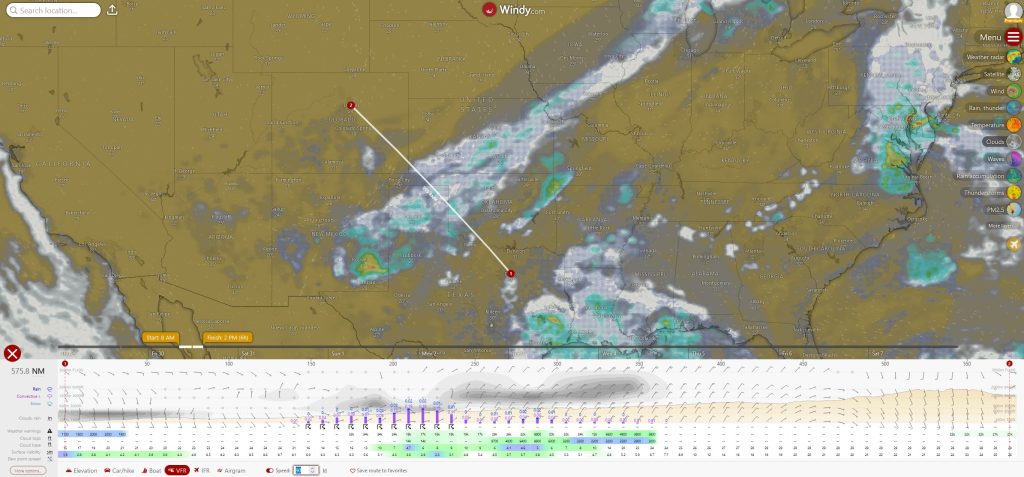
The tools we discussed above works great for understanding cloud coverage on your route of flight for a cross country. My favorite tool however, is Windy and its Distance & Planning feature. In the screenshot below, you see a flight schedule in the morning hours from Dallas to Denver. At the bottom, Windy gives you an histogram, a visual to see at which altitudes you may be dealing with clouds. You can very easily visualize if clouds will be a problem depending on your cruise altitude. Additionally it shows winds speeds and directions at altitude, chance of rain, thunderstorms or other weather phenomena. Looking at the histogram, I can say that we will have to deal with some convective activity in the middle of our route. It is clear that the convective activity is causing some cloud layers with potential chance for rain. At the bottom of the histogram, cloud tops, bases, and surface visibility is depicted in terms or feet and statute miles. You can also see terrain elevation rising as we are getting closer to Colorado. I use this tool exclusively a couple days before my planned cross country flight to determine if I need to make any changes to my departure time or day. You can learn more about Windy’s Distance & Planning feature in this community post.
SUMMARY
In your aviation journey, one of the most enjoyable flying you will be doing is in the clouds. Flying near clouds and in them are magical. So, as a flight instructor, I do not want my students to be afraid of the clouds. After all, you will be flying into them during your instrument training. I want my students to be respectful of clouds. Understand that clouds can overwhelm you as a VFR pilot and get you into trouble. Clouds will force you in a corner until you to make mistakes which may cost your life. To me, aviation, especially general aviation flying is all about understanding and balancing risks. Clouds represents high risks to VFR pilots especially those with low hours. Know your limits and act upon them. There is nothing wrong about deciding to cancel a local flight and simply doing pattern work at your home airport without leaving the safety of the pattern. Any practice is good practice. As I always say, never put yourself into a corner!
As always, let me know if you have any questions. Happy flying!